
![[Title] Catch the Tailwind! How to Check Wind Direction and Strength on the Shimanami Kaido](https://touring-shimanami.com/wp-content/uploads/2026/03/winde-ogp.png)
Worried about headwinds on the Shimanami Kaido? Learn about typical wind directions, when strong westerly winds occur, and why starting from Imabari gives you the best chance of a tailwind.
Hi, I’m Yuki Kawai — a touring cyclist based along the Shimanami Kaido. Having cycled this route more than 300 times, I created this site to share practical, experience-based tips for anyone planning a cycling trip here. I hope it helps you make the most of one of Japan’s most beloved cycling destinations.
Shimanami Kaido Cycling
Where is the Shimanami Kaido?
The “Shimanami Kaido” is a route connecting Onomichi City in Hiroshima Prefecture and Imabari City in Ehime Prefecture in western Japan. The islands floating between Honshu and Shikoku are linked by bridges, creating a route that cyclists and pedestrians can freely cross. Because of this unique setup, it is widely known as one of the world’s most famous cycling routes.
![[Photo] The wind of the Shimanami Kaido: Crossing giant bridges one after another and traveling to islands](https://touring-shimanami.com/wp-content/uploads/2025/01/shimanamiyado-5.jpg)
Along the route, you will find plenty of bicycle rental services and accommodations that welcome cycling travelers. Many rental bikes can be returned at a different terminal from where you started, making it easy to enjoy a one-way cycling trip—from Imabari to Onomichi, or from Onomichi to Imabari. This flexibility, combined with well-developed facilities for cyclists, is one of the reasons why the Shimanami Kaido is suitable for a wide range of travelers, from experienced cyclists to complete beginners.
![[Photo] Wind on the Shimanami Kaido: View of Tatara Bridge on the Hiroshima–Ehime prefectural border](https://touring-shimanami.com/wp-content/uploads/2023/05/shimanami-wind-2.jpg)
One of the biggest attractions of cycling the Shimanami Kaido is being able to travel at your own pace through the calm seas of the Seto Inland Sea and the peaceful scenery of its islands. Crossing several large bridges by bicycle—bridges that you would not normally experience in this way—is something truly unique to the Shimanami Kaido.
Should you start from Imabari or Onomichi?
If you want to cycle the entire Shimanami Kaido, one of the first questions you may face is “Should I start from Imabari or from Onomichi?”. Looking at travel blogs and social media posts by international visitors, many people seem to choose Onomichi as their starting point, partly because it is relatively easy to access.
![[Photo] Wind on the Shimanami Kaido: The Onomichi rental cycle terminal, a popular starting point](https://touring-shimanami.com/wp-content/uploads/2023/01/onomichistation-rt-3.jpg)
On the other hand, the well-known Shimanami Kaido cycling guidebook “Shimanami Toso Book” notes that starting from Imabari makes it easier to benefit from tailwinds. Many other websites also recommend beginning your ride in Imabari. In an article on my website about choosing a starting point, I also recommend starting from Imabari based on the elevation changes and typical wind patterns.

On this page, I’ve taken a closer look at the wind conditions along the Shimanami Kaido, one of the reasons I recommend starting from Imabari, including the risks and tendencies of headwinds.
- Typical wind direction and strength in the Shimanami Kaido area
- Why starting from Imabari is often recommended
- How to check the wind forecast in this area
A closer look at the meteorological data shows a clear pattern along the Shimanami Kaido: when winds come from the west, they tend to be stronger. On most days, however, winds are more often from the east, and in those cases the wind is usually relatively weak.
Understanding the wind will help you enjoy a more comfortable and safer ride on the Shimanami Kaido.
AD (Google AdSense)
Wind of Seto Inland Sea
First, let’s briefly look at the geography of the Seto Inland Sea—where the Shimanami Kaido is located—and the typical paths that wind travels through this area.
Typical wind patterns in the Seto Inland Sea
As the name “Setouchi Shimanami Kaido” suggests, this route crosses the Seto Inland Sea (Setouchi). On a map, it is located on the western side of the Seto Inland Sea. The Seto Inland Sea is an inland sea situated between two mountain ranges: the Chugoku Mountains on the Honshu side and the Shikoku Mountains on the Shikoku side. Because it is surrounded by land on all sides, the geography is sometimes compared to the Mediterranean Sea. Due to this unique landscape, the region is known in Japanese meteorology for a distinctive climate called the “Seto Inland Sea climate.”
![[Illustration] Wind on the Shimanami Kaido: Typical wind paths in the Seto Inland Sea](https://touring-shimanami.com/wp-content/uploads/2025/06/windshimanami-1024x730.png)
Winds blowing from the Pacific Ocean or the Sea of Japan are often blocked by these mountain ranges. As a result, the wind tends to flow around the mountains and pass through natural corridors such as the Kanmon Strait (between Honshu and Kyushu), the Bungo Channel (between Shikoku and Kyushu), and the Kii Channel (between Shikoku and Honshu). Because of this, winds in the Seto Inland Sea region tend to blow from the east or from the west.
Because the Seto Inland Sea is surrounded by the Chugoku Mountains and the Shikoku Mountains, winds are said to blow more easily in an east–west direction rather than north–south.
With these characteristics in mind, let’s next take a look at actual meteorological data from the Japan Meteorological Agency (JMA) to understand the wind directions and wind strength that can affect cycling on the Shimanami Kaido.

Looking at the data, it seems there is a significant difference in wind direction between normal days and days when strong winds occur.
AD (Google AdSense)
Winds on the Shimanami Kaido
The westerly wind is a tailwind for departing from Imabari
First, let’s check the relative positions of the two ends of the Shimanami Kaido: Imabari and Onomichi. If you look at a map, you’ll see that Imabari on the Shikoku side is located slightly farther west than Onomichi.
![[Illustration] Wind on the Shimanami Kaido: The route is located on the western side of the Seto Inland Sea](https://touring-shimanami.com/wp-content/uploads/2025/06/locationofshimanami.png)
In simple terms, a westerly wind tends to create a tailwind when starting from Imabari, while an easterly wind tends to favor starting from Onomichi.
Wind characteristics of the Shimanami Kaido
The website of the JMA (Japan Meteorological Agency) provides access to historical weather data. By looking at the AMeDAS observation data for Omishima, Ikuchijima, and Imabari, you can see detailed weather trends for the Shimanami Kaido area by year, month, and day. Since this dataset also includes information on “wind direction and wind speed,” I referred to these records for this article.
The most common wind direction: easterly
![[Screenshot] Wind on the Shimanami Kaido: Northeasterly wind over the route (Windy.com)](https://touring-shimanami.com/wp-content/uploads/2024/02/mukaikaze-windy.jpg)
I analyzed weather data from three locations—Omishima, Imabari, and Ikuchijima—covering the period from January 1, 2022 to December 31, 2025. The following table shows the prevailing wind directions that most often appear on calm days (average wind speed of 3 m/s or less).
| Location | Main Wind Direction on Calm Days | Findings from the 2022–2025 Analysis |
|---|---|---|
| Ikuchijima | Northeast / East-northeast / East | Similar to Omishima, winds from the northeast sector are common, and these are generally light winds. |
| Omishima | Northeast | On many days the prevailing wind direction concentrates in the northeast, with average wind speeds remaining relatively stable and gentle at around 1.5–2.5 m/s. |
| Imabari | East-northeast / East / East-southeast | On calm days, easterly winds occur most frequently and appear as the prevailing wind direction. |
First, I looked at the “most frequent wind direction,” meaning the direction the wind blows most often. The exact pattern varies slightly depending on the season and the specific AMeDAS observation point, but in this area the most common winds tend to come from the east—such as northeast, east, or north-northeast. Looking at the data for Omishima during August to October, when many people cycle the Shimanami Kaido, the most frequent wind direction is overwhelmingly “northeast.”
![[Illustration] Wind on the Shimanami Kaido: Typical easterly winds in the Seto Inland Sea and the Shimanami Kaido](https://touring-shimanami.com/wp-content/uploads/2026/03/shimanamiwind-1.png)
Of course, the exact wind pattern depends on the day’s atmospheric pressure systems. However, it seems common for winds to flow in from relatively low-lying areas around the Kii Channel and the Kansai region, then pass through the Seto Inland Sea from east to west. At first glance, then, it might seem that starting from Onomichi and heading toward Imabari would give you a tailwind more often, making the ride feel easier.
Strongest winds often come from the west
However, if we look at the “maximum wind direction,” meaning the direction of the wind when the strongest gusts occur, a different pattern appears. At all three observation points—Omishima, Ikuchijima, and Imabari—the monthly records show that the maximum wind direction is overwhelmingly “west-southwest,” in other words winds from the west. This suggests that stronger winds often occur when air flows through the Bungo Channel, the sea passage between Kyushu and Shikoku.
| Location | Main Wind Direction During Strong Winds | Findings from the 2022–2025 Analysis |
|---|---|---|
| Ikuchijima | Southwest / West-southwest | During strong wind events, winds from the southwest sector are very common, and there are occasional days when maximum wind speeds reach around 10 m/s. |
| Omishima | West-southwest / Southwest | When maximum wind speeds increase, winds from the west-southwest or southwest are common, sometimes exceeding 10 m/s. |
| Imabari | West-northwest / West | On days when the maximum wind speed exceeds 10 m/s, the wind is almost consistently from the west-northwest. |
Easterly winds may be less likely to become very strong because the path the wind travels across the Seto Inland Sea is longer and there are many islands along the way. In contrast, when westerly winds blow, the distance from the Pacific Ocean is shorter and there are fewer obstacles, which may allow the wind to become stronger.
![[Illustration] Wind on the Shimanami Kaido: Typical westerly winds in the Seto Inland Sea and the Shimanami Kaido](https://touring-shimanami.com/wp-content/uploads/2026/03/shimanamiwind-2.png)
Looking at the meteorological data, on days when the wind tends to become stronger, starting from Imabari and heading toward Onomichi is more likely to give you a helpful tailwind. Conversely, if you start from Onomichi on such a day, you may encounter a strong headwind, which could drain your energy and take more time than you expected.
On the Shimanami Kaido, winds from the west tend to be stronger. Easterly winds occur more often, and on those days the wind is usually relatively mild.
Starting from Imabari is often recommended
To summarize the points above, the wind around the Shimanami Kaido seems to follow a pattern: “most days have relatively gentle winds from the east, but occasionally strong winds blow from the west.” Considering that strong winds have a greater impact on cycling, starting from Imabari and heading toward Onomichi may reduce the risk of facing a strong headwind.
![[Illustration] Wind on the Shimanami Kaido: The most common winds are easterly, while the strongest winds tend to come from the west](https://touring-shimanami.com/wp-content/uploads/2026/03/winddir.png)
This also explains why so many guides and travel resources recommend Imabari as the better starting point. The idea is supported by actual meteorological observation data. From my own experience cycling the Shimanami Kaido many times, I also feel that the toughest headwinds tend to occur when riding toward Imabari.
![[Photo] Wind on the Shimanami Kaido: The rental cycle terminal in front of Imabari Station, often used as a starting point](https://touring-shimanami.com/wp-content/uploads/2023/05/shimanami-wind-3.jpg)
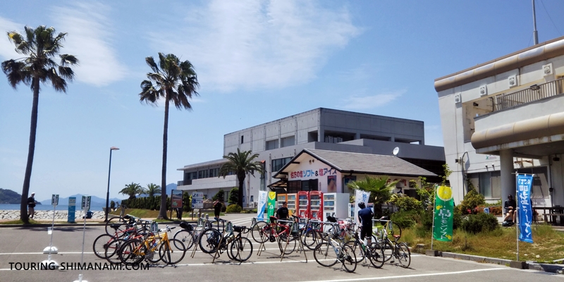
If you rent a bicycle in Imabari, the public rental system (Shimanami Rental Cycle) has two locations: the “Imabari Station Cycling Terminal” and “Sunrise Itoyama.” For cross bikes and city bikes, you can return the bicycle not only in Onomichi but also at other rental cycle terminals along the Shimanami Kaido route.
| Rental Cycle Terminal | Imabari Station Rental Cycle | Imabari Itoyama Rental Cycle |
|---|---|---|
| Facility | Imabari Station i.i.imabari! Cycle Station | Sunrise Itoyama |
| Address | 2-773-8 Kitahorai-cho, Imabari City | 2-8-1 Sunaba-cho, Imabari City |
| Opening Hours | 8:00–19:00 (until 18:00 in winter) | 8:00–19:00 (until 18:00 in winter) |
| Bike Types Available | Cross bikes, city bikes, electric-assist bikes, e-bikes | Cross bikes, city bikes, electric-assist bikes, e-bikes, tandem bikes, children’s bikes, etc. |
| Access | Located directly in front of Imabari Station, less than a 1-minute walk. The Blue Line cycling route also starts right nearby. | Public transportation access is somewhat limited. Local buses run infrequently, so please plan accordingly. |
*[Winter season] From December to February, some terminals have shorter opening hours.
AD (Google AdSense)
Seasonal wind characteristics
As explained above, the general airflow in the upper atmosphere follows broad regional patterns. However, closer to the ground—where you actually cycle—wind direction and speed are strongly influenced by local terrain. The Shimanami Kaido area in particular has a complex landscape with many islands of different sizes. Winds may wrap around the islands or blow downward from the mountains located near the centers of some islands.
Seasonal wind patterns
Spring (March–May) is generally a season with many calm days. However, around March, a strong southerly wind known as the “Spring First Storm” (Haru Ichiban) may occur. According to the Matsuyama Local Meteorological Observatory, summer (June–August) is strongly influenced by “sea–land breezes,” which are caused by temperature differences between the sea and the land. During the daytime, a sea breeze often blows from the sea toward the land, while at night a land breeze blows from the land toward the sea. Because of this, wind direction can change depending on the time of day. In my experience, mornings are often relatively calm.
![[Photo]Cycling on the Shimanami Kaido in winter—winds can be stronger?](https://touring-shimanami.com/wp-content/uploads/2025/12/wintershima-3.jpg)
Autumn (September–November) is a season when winds are generally stable, except immediately after a typhoon passes through. As it is also a popular travel season, it’s easy to see why many people choose this time of year to visit the Shimanami Kaido. Winter (December–February) can bring strong northwesterly seasonal winds when the typical “west-high, east-low” pressure pattern develops over Japan. On the other hand, there are also very calm days with almost no wind, so conditions can vary greatly from day to day. During this season, it is especially important to check the wind forecast the day before your ride or on the morning of your departure.
| Season | Period | Characteristics |
|---|---|---|
| Spring | March–May | Many calm days (watch out for strong “spring first” winds) |
| Summer | June–August | Strong influence of sea–land breezes |
| Autumn | September–November | Relatively stable (beware of typhoons) |
| Winter | December–February | Large variation between strong winds and calm days |
I have summarized the seasonal wind characteristics for Imabari, Omishima, and Ikuchijima from 2022 to 2025 in more detail below. If you are interested in this kind of data, the information may serve as a useful reference.
| Season | Period | Wind Characteristics and Trends |
|---|---|---|
| Spring | March–May | Wind direction changes frequently, with occasional strong westerlies. In March, strong westerly winds sometimes remain from winter weather patterns. By April and May, calmer easterly winds become more common, but the passage of low-pressure systems can bring sudden gusts from the southwest or west-northwest (typical spring storms). |
| Summer | June–August | The calmest season of the year, with mainly easterly winds. On many days, winds from the northeast sector appear as the prevailing direction, and the average wind speed remains relatively stable at around 1.5–2.5 m/s. This is generally the season with the least wind impact for cycling, although strong southwest winds can temporarily occur when typhoons approach or toward the end of the rainy season. |
| Autumn | September–November | Many calm easterly winds, but watch for strong winds in September. In October and November, gentle easterly winds are common and many days are comfortable for cycling. However, in September, typhoons and the autumn rain front can occasionally cause very strong winds from the east to northeast, with maximum wind speeds exceeding 10 m/s. From late November onward, westerly winds gradually become more frequent. |
| Winter | December–February | Strong seasonal winds from the west to west-northwest dominate. This is the windiest season of the year and can significantly affect cycling conditions. In particular, strong west-northwest winds are common in Imabari, while southwest to west-southwest winds often occur around Ikuchijima and Omishima. Maximum wind speeds exceeding 10 m/s are not unusual. |
Looking at the detailed analysis, from March to May and from December to February, strong westerly winds occur quite frequently. Because of this, starting from Imabari—where you are more likely to benefit from a tailwind—may make the ride easier. In particular, starting from Onomichi during winter carries the risk of facing strong headwinds for most of the route.
From June to November, easterly winds generally dominate, but they are often relatively light (around 3 m/s or less). Therefore, except during the typhoon season in September, there is usually little difference in choosing either starting point.
The advantages and precautions of cycling the Shimanami Kaido in winter are summarized on this page.

On the Shimanami Kaido, strong winds tend to blow from west to east.
AD (Google AdSense)
Are the bridges especially windy?
Compared with the roads on the islands, the bridges that cross the straits are particularly exposed to the wind. Because there is nothing around to block the wind, it often feels much stronger on the bridges than on the island roads.
The experience varies from bridge to bridge, but special attention is needed on the Kurushima Kaikyo Bridge. With a total length of about 4 km, it is the longest bridge on the Shimanami Kaido, meaning you spend more time riding on the bridge than anywhere else along the route. On windy days, simply crossing the bridge can require a considerable amount of energy.
![[photo] Cycling lane on the Kurushima Kaikyo Bridge](https://touring-shimanami.com/wp-content/uploads/2023/11/ugokiyasui-fukusou.jpg)
The cycling lanes on the bridges are relatively narrow, and you will often pass cyclists traveling in the opposite direction. Passing each other in strong crosswinds can sometimes lead to unexpected contact, so please ride carefully. Try not to ride too close to the railing side, and if the wind is strong, slow down and ride cautiously.
If the wind feels too strong or scary, you do not need to keep riding. You can always get off your bike and walk while pushing it. Even at a slow pace, you will still be able to cross the bridge safely. Always prioritize safety and cross the bridge at a comfortable pace.
AD (Google AdSense)
Three ways to deal with headwinds
Ideally, you would plan your ride with headwinds in mind. In reality, however, conditions are not always clear until you actually start riding. If you find yourself thinking, “The wind is stronger than I expected,” it helps to know a few ways to deal with it so you can respond calmly.
① Slow down and take more breaks
For cyclists, riding into a headwind often feels similar to continuously climbing a gentle uphill. The wind does not have to come directly from the front—winds blowing from a diagonal direction can also create strong resistance. Compared with riding with a tailwind, the rate at which you use up your energy is clearly different.
![[photo] Cycling where the direction of travel gradually changes](https://touring-shimanami.com/wp-content/uploads/2025/11/omishima-north-12.jpg)
However, when cycling across the islands of the Shimanami Kaido, your direction of travel changes slightly each time you cross a bridge. Even if one section feels difficult because of a headwind, the wind direction may shift on the next island and make the ride easier. Try not to assume that the same strong headwind will continue the entire way—just keep riding steadily without rushing.
In sections with strong headwinds, it’s best not to force yourself to maintain your usual pace. Instead, slow down and take more frequent breaks than usual. Along the Shimanami Kaido you’ll find rest stops called “Cycle Oasis,” and convenience stores and vending machines are also good places for a short break. Use these stops to conserve your energy and keep your ride enjoyable. As always, allowing extra time in your schedule makes a big difference.
② Take a ferry shortcut
I have personally experienced several rides on the Shimanami Kaido where strong headwinds caused me to arrive two or three hours later than planned. If you begin to feel that “I won’t make it before sunset at this rate,” it may be wiser to consider taking a ferry shortcut rather than forcing yourself to keep pedaling.
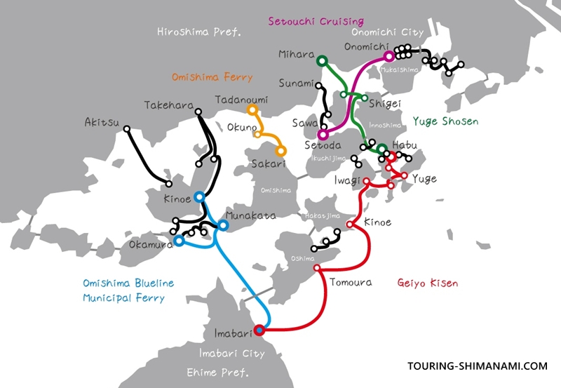
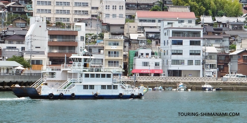
There are several ferry and passenger boat routes connecting the islands in the Shimanami Kaido area. While it is usually difficult to bring a bicycle onto a bus, ferries allow you to board with your bicycle. Taking a boat partway through your trip is not “cheating” at all—it is a perfectly valid and practical way to travel during your ride.
I have summarized the ferry routes around the Shimanami Kaido on another page of my website. Taking a quick look before your trip can help you avoid stress if you ever need an alternative plan. Simply knowing that “there is always a ferry option” can give you peace of mind while riding.
③ Avoid strong winds by timing your ride
When you check the wind forecast, there are days when it looks like “the wind will get stronger in the afternoon.” In such cases, a good strategy is to cover as much distance as possible during the morning.
Early mornings and evenings are often calm periods known as “nagi,” when the wind becomes relatively gentle. On the other hand, winds are often said to strengthen around midday as sunlight warms the ground. This pattern is especially noticeable in places like the Shimanami Kaido, where the islands are completely surrounded by the sea and winds can easily form due to temperature differences between the land and the water.
For conserving your energy and enjoying a more relaxed cycling pace, it is best to start your ride as early as possible in the morning. Many public rental cycle terminals open at 8:00 a.m. If you can rent your bike at 8:00 and set off by around 8:30, that would be ideal.
The air is often clear in the morning and the scenery looks especially beautiful. It’s also my personal favorite time of day to ride.
AD (Google AdSense)
Checking wind forecasts
Check wind forecasts alongside weather forecasts
Once your cycling dates on the Shimanami Kaido are set, one of the first things to check before your trip is the weather forecast. Most people check whether it will be sunny or if there is a chance of rain. However, for cycling trips, it’s also recommended to check the wind forecast. This is a detail that novice cyclists often overlook, but wind direction and strength can greatly affect both the comfort of your ride and the time it takes to complete it.
Depending on your accommodations and transport, it might be difficult to change your starting point at the last minute. Still, by checking the wind forecast, you can plan alternative options such as taking a ferry for a shortcut or adjusting your route. If strong headwinds are expected, it’s wise to anticipate a longer travel time and build extra buffer into your schedule for a safer, more enjoyable ride.
Wind forecasts made easy with “Windy”
For checking wind forecasts, the web service “Windy.com” (also available as a smartphone app) is extremely useful. It provides highly accurate wind direction forecasts using meteorological prediction models, and you can access it for free. Around the Shimanami Kaido, the wind patterns are shown in visually intuitive graphics, making it perfect for pre-trip planning. The service supports both Japanese and English, so it’s easy for travelers from overseas to use as well.
![[Screenshot] Wind on the Shimanami Kaido: Checking wind forecasts with Windy](https://touring-shimanami.com/wp-content/uploads/2023/05/wind-shimanami.jpg)
The islands along the Shimanami Kaido have complex terrain, so localized winds that swirl around islands may cause the actual experience to differ from the forecast. While the free version may not fully reflect such fine-scale terrain effects, it is still very helpful for understanding the overall wind trends.
Wind speed and how it feels when cycling
When checking wind speed on websites such as Windy or the Japan Meteorological Agency, it helps to understand how those numbers might affect your cycling. The following impressions are based on my personal experience, but they may serve as a useful reference when planning your ride.
| Wind Speed | How It Feels |
|---|---|
| 3 m/s | Almost no problem |
| 5 m/s | Slightly tough |
| 8 m/s | Headwinds become quite difficult |
| 10 m/s | Beginners should be cautious |
Around 3 m/s, even a headwind usually does not create much resistance. You may feel a light breeze, but cycling is generally comfortable. When the wind reaches around 5 m/s, however, a headwind begins to feel noticeably harder. You may tire more quickly than usual, so it is a good idea to take breaks more frequently.
At wind speeds of 8 m/s or more, riding into a headwind becomes quite difficult and can quickly drain your energy. For those who are new to long-distance cycling on a road bike or other sports bicycle, this situation may feel especially challenging. At 10 m/s or more, the wind can begin to affect bike handling itself. Extra caution is needed when riding on bridges, and in some cases the bridge may even be closed to traffic.
One more quick note about how wind direction is expressed in weather forecasts. An “east wind” means a wind that blows from the east toward the west, while a “west wind” blows from the west toward the east. Because the direction refers to where the wind comes from, it can sometimes feel a little counterintuitive at first.
Be sure to check wind forecasts along with the weather before your ride!
Closures due to strong winds
The dedicated cycling and pedestrian paths on the bridges along the Shimanami Kaido may be closed if strong winds are expected (Approximately once or twice a year). In most cases, these temporary closures are due to strong winds or typhoons. According to the Honshu-Shikoku Expressway website, all bridge traffic—including cars—is closed when the 10-minute average wind speed is forecast to exceed 25 m/s. When winds exceed 15 m/s, two-wheeled vehicles are restricted from crossing.
For cycling and pedestrian paths specifically, the exact wind speed threshold for closure has not been publicly announced. It is likely similar to the restrictions for two-wheeled vehicles on expressways, but there are cases where only the cycling/pedestrian paths (including mopeds) are restricted. If wind speed is the determining factor, the threshold may be stricter than the 15 m/s used for two-wheeled vehicles.
AD (Google AdSense)
Frequently asked questions
- QShould I cancel my ride if there is a strong headwind?
- A
If the headwind is moderate, you can still enjoy cycling on the Shimanami Kaido. A bicycle will simply slow down—you will not suddenly become unable to move forward. However, if strong headwinds continue for a long time, they can quickly drain your energy. In such situations, it is a good idea to avoid pushing too hard, take more frequent breaks, or consider shortening your route by using a ferry or bus.
- QWhere is the windiest place on the Shimanami Kaido?
- A
In general, bridges that run long distances over the sea tend to be the most exposed to wind. From my own experience, I have often felt particularly strong winds on long bridges such as the Kurushima Kaikyo Bridge and Tatara Bridge. On the islands themselves, coastal roads are also more likely to be windy. In places where islands are close together, the straits between them can act like wind corridors.
- QCan you cross the bridges during a typhoon or very strong winds?
- A
If extremely strong winds occur, such as during a typhoon, the bicycle paths on the bridges may be temporarily closed. This is a safety measure, so in that case you will need to cancel your ride or change your schedule. However, closures due to wind are actually quite rare. For example, the bicycle path on the Kurushima Kaikyo Bridge is typically closed only once or twice a year. It is a good idea to check the official websites or social media of the Honshu–Shikoku Bridge Expressway Company or Shimanami Japan for updates.
- QDo you have any tips for cycling on windy days?
- A
On windy days, the key is not to push for speed but to ride at a slower pace than usual. When facing a headwind, shifting to a lighter gear and increasing your pedaling cadence—similar to climbing a hill—can help reduce strain on your body. If you are using an electric-assist bicycle, increasing the assist level by one step can also help. Be aware that crosswinds can occur on bridges, so keep a firm grip on the handlebars and maintain a stable riding position.
AD (Google AdSense)
Reference: Daily Wind Data for Omishima by Season
The wind directions and wind strength trends I’ve described so far are based on an analysis of AMeDAS observation data from the Japan Meteorological Agency (JMA), covering the years 2022–2025. Showing all of that data would be far too much for one page, so as an example, I’ve picked out one representative week for each season from the observation data for Omishima, which sits roughly at the midpoint of the Shimanami Kaido, to illustrate the wind characteristics typical of spring, summer, autumn, and winter.
Spring wind data (a week with shifting wind directions: early May 2023)
In early May, winds around Omishima are usually a gentle northeast, but on days when a traveling low-pressure system passed through, a west-southwest wind temporarily picked up. It’s a week that captures the changeable, springlike feel of shifting wind directions fairly well.
| Date | Avg. Wind Speed (m/s) | Max. Wind Speed (m/s) | Direction at Max. Speed | Prevailing Direction |
|---|---|---|---|---|
| May 1, 2023 | 1.8 | 4.2 | West-southwest | Northeast |
| May 2, 2023 | 1.6 | 3.8 | Northeast | Northeast |
| May 3, 2023 | 1.5 | 3.5 | East-northeast | Northeast |
| May 4, 2023 | 2.5 | 6.0 | West-southwest | West-southwest |
| May 5, 2023 | 1.9 | 4.5 | West-southwest | Northeast |
| May 6, 2023 | 2.2 | 4.8 | Southwest | Northeast |
| May 7, 2023 | 1.7 | 4.0 | North-northeast | Northeast |
Summer wind data (a week of calm easterly winds: mid-August 2023)
In mid-August, just after the Obon holiday, a gentle northeasterly wind continued around Omishima for the entire week. The average wind speed stayed close to 2 m/s on most days, which reflects the data showing this is the easiest season of the year for riding.
| Date | Avg. Wind Speed (m/s) | Max. Wind Speed (m/s) | Direction at Max. Speed | Prevailing Direction |
|---|---|---|---|---|
| Aug 13, 2023 | 1.6 | 3.5 | Northeast | Northeast |
| Aug 14, 2023 | 1.8 | 3.8 | Northeast | Northeast |
| Aug 15, 2023 | 1.5 | 3.2 | East-northeast | Northeast |
| Aug 16, 2023 | 1.7 | 3.9 | West-southwest | Northeast |
| Aug 17, 2023 | 1.9 | 4.1 | Southwest | Northeast |
| Aug 18, 2023 | 1.6 | 3.6 | Northeast | Northeast |
| Aug 19, 2023 | 1.8 | 4.0 | North-northeast | Northeast |
Autumn wind data (a stable cycling-season week: mid-October 2023)
Mid-October, right in the middle of the cycling high season, was also a stable week centered on northeasterly winds, just like summer. There were days when the maximum wind speed picked up a little, but it generally stayed under around 4 m/s—conditions that felt comfortable for riding most of the week.
| Date | Avg. Wind Speed (m/s) | Max. Wind Speed (m/s) | Direction at Max. Speed | Prevailing Direction |
|---|---|---|---|---|
| Oct 15, 2023 | 1.7 | 3.8 | Northeast | Northeast |
| Oct 16, 2023 | 1.4 | 3.1 | Northeast | Northeast |
| Oct 17, 2023 | 1.6 | 3.5 | East-northeast | Northeast |
| Oct 18, 2023 | 1.5 | 3.3 | Northeast | Northeast |
| Oct 19, 2023 | 1.9 | 4.2 | West-southwest | Northeast |
| Oct 20, 2023 | 1.8 | 4.0 | North-northeast | Northeast |
| Oct 21, 2023 | 1.5 | 3.4 | East-northeast | Northeast |
Winter wind data (a week with strong westerly seasonal winds: late December 2023)
Late December, on the other hand, when winter-type pressure patterns strengthened, brought west-southwest and southwest winds day after day, with the maximum wind speed topping 10 m/s on some days. I think this is precisely the kind of week that explains why I recommend starting from Imabari, since it shows the west wind of winter doing exactly what the data suggests it will.
| Date | Avg. Wind Speed (m/s) | Max. Wind Speed (m/s) | Direction at Max. Speed | Prevailing Direction |
|---|---|---|---|---|
| Dec 20, 2023 | 2.5 | 6.5 | West-southwest | Southwest |
| Dec 21, 2023 | 4.2 | 10.5 | West-southwest | West-southwest |
| Dec 22, 2023 | 3.8 | 9.2 | Southwest | West-southwest |
| Dec 23, 2023 | 3.5 | 8.8 | West-southwest | West-southwest |
| Dec 24, 2023 | 1.9 | 4.5 | West-southwest | Northeast |
| Dec 25, 2023 | 2.8 | 7.0 | Southwest | West-southwest |
| Dec 26, 2023 | 3.2 | 8.5 | West-southwest | West-southwest |
These are just sample weeks, but I picked ones that show the seasonal patterns I’ve been describing fairly clearly.
On this page, I explored the winds along the Shimanami Kaido, including typical wind directions, wind strength, and considerations for choosing between starting at Imabari or Onomichi. For more detailed cycling information suitable for beginners to experienced riders, please check the following page—it’s a helpful resource for planning your ride.